More storms expected tonight, weekend looks drier


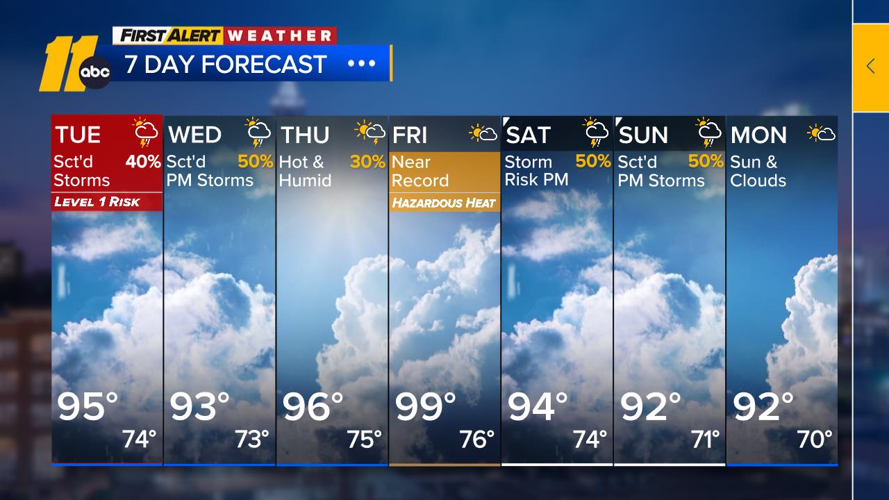
ABC11 Meteorologist Don "Big Weather" Schwenneker says after two days of strong thunderstorms, just about the entire state is under a slight risk for severe weather late this afternoon and evening once again.
Click here for weather alerts from the National Weather Service.
Click here for First Alert Doppler XP
Click here to download the ABC11 First Alert Weather app.
Schwenneker says a cold front will approach Friday and as it slices into a very moist and unstable air mass, additional showers and thunderstorms are likely.
"They will be widespread late afternoon and into tonight," he said. "Rain will be locally heavy, with high winds and hail possible in spots. The National Weather Service's Storm Prediction Center has again put us under a slight risk for severe weather."
The cold front will move slowly to the south late Friday night and Saturday.
"Tomorrow will not be as warm as today, but the humidity will not drop off a lot," Schwenneker said. "Therefore, we could still get a shower or thunderstorm in a few spots int the morning, but drier, less humid air should win out for the afternoon and Sunday."
Storms moved through the Triangle and nearby areas late Thursday night.

The National Weather Service issued a tornado warning for Orange, Chatham, and Alamance counties, but there were no immediate reports of damage. Later in the evening, a tornado warning was issued for Granville County.
RELATED: WHAT TO DO WHEN A TWISTER STRIKES
In Raleigh, live power lines were reported down on Highway 98 near Loblolly Pine Drive, closing the westbound lane.
Raleigh police also said trees were down in several places, including Strickland Road and Creedmoor Road, in the 400 block of Hensley Drive, at Summerton Drive and Crisp Drive, in the 3200 block of Fairhill Drive and Waterwood Court and Fonville Road.