First Alert Day: Dangerous heat, storms possible as heat index nears 110

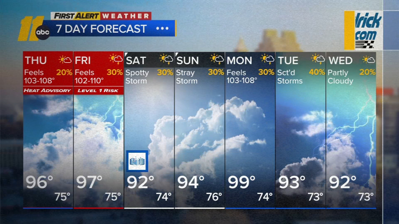
RALEIGH, N.C. (WTVD) -- First Alert-Dangerous Heat & Storms: Afternoon highs will be around the mid 90s with feels-like temps as high as 110. Additionally, isolated to scattered showers and storms are possible Friday. There is a Level 1 of 5 severe storm risk, with damaging winds and localized flooding as the main threats.
Good Thursday morning! Out-the-door temps are in the upper 60s to mid 70s. Highs will reach the low to mid 90s under a mix of sun and clouds. Feels-like temps will climb as high as 108 this afternoon. Any thunderstorm activity will be spotty.
Friday should be dry through the early afternoon hours. Highs will be in the mid/upper 90s. Storm chances increase Friday evening as a disturbance moves in from the north and west. There is Level 1 of 5 severe risk Friday for damaging winds.
Isolated to widely scattered late-day storms will be possible Saturday as a front moves closer.
Highs will be in the low to mid 90s this weekend behind the front, but will spike again Monday ahead of another front with highs approaching 100 degrees. The chance for thunderstorms may still be greatest on Monday, but the question remains how widespread the activity will be.
There could be a thunderstorm in spots on Tuesday before we finally look to have a dry day on Wednesday, when humidity may drop, though it looks like the humidity will quickly return.
Tropics:
Cristobal: The depression is west of the Azores and is moving toward the northeast near 16 mph. This general motion is expected to continue through today. Maximum sustained winds are near 35 mph (55 km/h) with higher gusts. Weakening is forecast, and Cristobal is forecast to dissipate later today.
1. Central Tropical Atlantic (AL92):
Showers and thunderstorms associated with a tropical wave located
midway between the Lesser Antilles and the west coast of Africa
have become a little better organized since yesterday.
Environmental conditions are forecast to be conducive for further
development during the next day or so, and a tropical depression
will likely form while the system moves westward to west-
northwestward across the central tropical Atlantic. Beginning on
Friday, upper-level winds are likely to become too strong for
development as the system approaches the Lesser Antilles.
* Formation chance through 48 hours...high...80 percent.
* Formation chance through 7 days...high...80 percent.

2. Eastern Tropical Atlantic (AL94):
A tropical wave located a few hundred miles south of the Cabo Verde
Islands is producing disorganized showers and thunderstorms.
Environmental conditions are forecast to be generally conducive for
some development, and a tropical depression could form late this
week or this weekend while the wave moves westward or west-
northwestward across the eastern and central tropical Atlantic.
* Formation chance through 48 hours...low...30 percent.
* Formation chance through 7 days...medium...50 percent.
Have a great day!
Kweilyn