Early September heatwave inbound for Central NC

RALEIGH, N.C. (WTVD) -- First Alert-Fog: Areas of dense morning fog will be possible until 9am Monday.
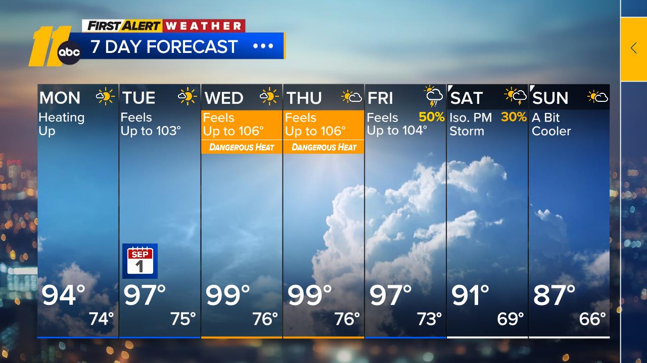
First Alert-Dangerous Heat: High heat and humidity will return Tuesday and last through Friday. Expect highs in the mid to upper 90s with heat indices of 100 to 110 each day.
Temperatures will continue to rise today as a strong ridge of high pressure out west continues to shift east. Highs today will climb into the low to mid 90s.
A pattern more often seen during the early part of summer rather than September begins Tuesday and will bring temperatures near 100 degrees through the middle of the week. Record high temperatures will be challenged Wednesday and Thursday as the core of the high settles overhead. There is a chance that clouds developing over the mountains could drift into the Triangle during the afternoons around midweek, which would help limit temperatures somewhat, though it will be partly to mostly sunny most of the time.
The ridge will retrograde westward into the weekend, and a cold front will approach Friday, bringing rain/storm chances Friday and Saturday.
Temperatures will return closer to the historical average of 85 degrees as we head into Labor Day, with some guidance suggesting humidity could drop for the holiday.
Tropics: For the North Atlantic...Caribbean Sea and the Gulf:
1. Northern Gulf of America (AL97):
An area of low pressure over the northern Gulf of America, located
more than 100 miles south of the coast of southern Louisiana
continues to produce a small but concentrated area of showers and
thunderstorms. Earlier satellite wind data indicated that the
circulation has not become much better defined from yesterday while
producing winds of 30 to 35 mph. Regardless, additional development
is anticipated as the low moves slowly west-northwestward, and a
short-lived tropical depression or tropical storm is likely to form
before the system reaches the Upper Texas or southwestern Louisiana
coasts by tonight or Tuesday morning.
Interests along the southwest Louisiana and Upper Texas coasts
should monitor the progress of this system, as tropical storm
watches or warnings could be required for portions of the area later
today. Regardless of development, this system is expected to bring
locally heavy rainfall to portions of the Upper Texas and
southwestern Louisiana coasts during the next several days. An Air
Force Reserve reconnaissance aircraft is scheduled to investigate
the system later this morning. Additional information on this
system, including gale warnings, can be found in High Seas Forecasts
issued by the National Weather Service.
* Formation chance through 48 hours...high...70 percent.
* Formation chance through 7 days...high...70 percent.


2. Near Puerto Rico and the Virgin Islands (Remnants of Dolly):
The remnants of Tropical Storm Dolly, a surface trough of low
pressure, continues to produce an area of showers and thunderstorms
from Hispaniola eastward to the northern Leeward Islands. Strong
upper-level winds are expected to prevent redevelopment of this
system over the next day or two while it moves quickly westward to
west-northwestward at 20 to 25 mph. Conditions could become more
conducive for redevelopment by the middle of the week as the system
reaches the southern Bahamas or Florida Straits. Regardless, the
system could bring locally heavy rains and gusty winds to portions
of the Leeward Islands, the Virgin Islands, Puerto Rico, and
Hispaniola over the next couple of days.
* Formation chance through 48 hours...low...near 0 percent.
* Formation chance through 7 days...low...20 percent.
Have a great day!
Kweilyn