Central NC braces for major winter storm with snow, ice and record-breaking cold

RALEIGH, N.C. (WTVD) -- See live weather updates here.
Millions of Americans from New Mexico to the Carolinas are bracing for a potentially catastrophic ice storm that could crush trees and power lines and knock out power for days, while Washington, D.C., Philadelphia, New York City and Boston could see enough snow to make travel very difficult or nearly impossible, forecasters say.
About 160 million people - nearly half the population of the United States - were under a variety of watches, warnings and other alerts associated with the winter storm, the National Weather Service announced Thursday afternoon. The alerts stretched from Arizona and Montana in the West to the Carolinas and Maine in the east.
The storm, expected to begin Friday and continue through the weekend, is also projected to bring heavy snow and all types of wintry precipitation, including freezing rain and sleet. An atmospheric river of moisture could be in place by the weekend, pulling precipitation across Texas and other states along the Gulf Coast and continuing across Georgia and the Carolinas before heading northeast, forecasters said.
Parts of at least 19 states in the storm's path were under winter storm watches by late Wednesday, with more watches and warnings expected as the system approaches.
The number of major U.S. hub airports in the path of the southern storm this weekend, when ice, sleet and snow could delay passengers and cargo, including at Charlotte Douglas International Airport. Still more major airports on the East Coast could see delays later, as the storm barrels east.
Download the ABC11 for breaking news and weather alerts
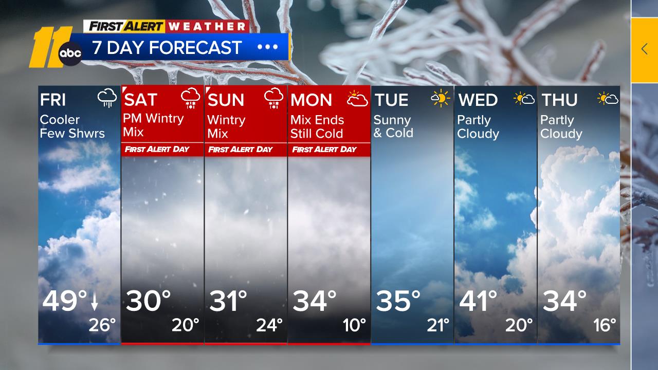
Central NC forecast
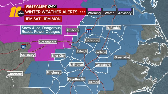
Governor Josh Stein has declared a State of Emergency as a Winter Storm Watch was issued for all of Central North Carolina Saturday afternoon through Monday.
"I encourage all North Carolinians to stay home and off the roads this weekend unless absolutely necessary so first responders can do their jobs safely and effectively," the governor said in a news release. Crews across the state are out brining roads and bridges, but officials warned impacts will likely linger into next week.
SEE ALSO | How to prepare a winter weather safety kit for the season
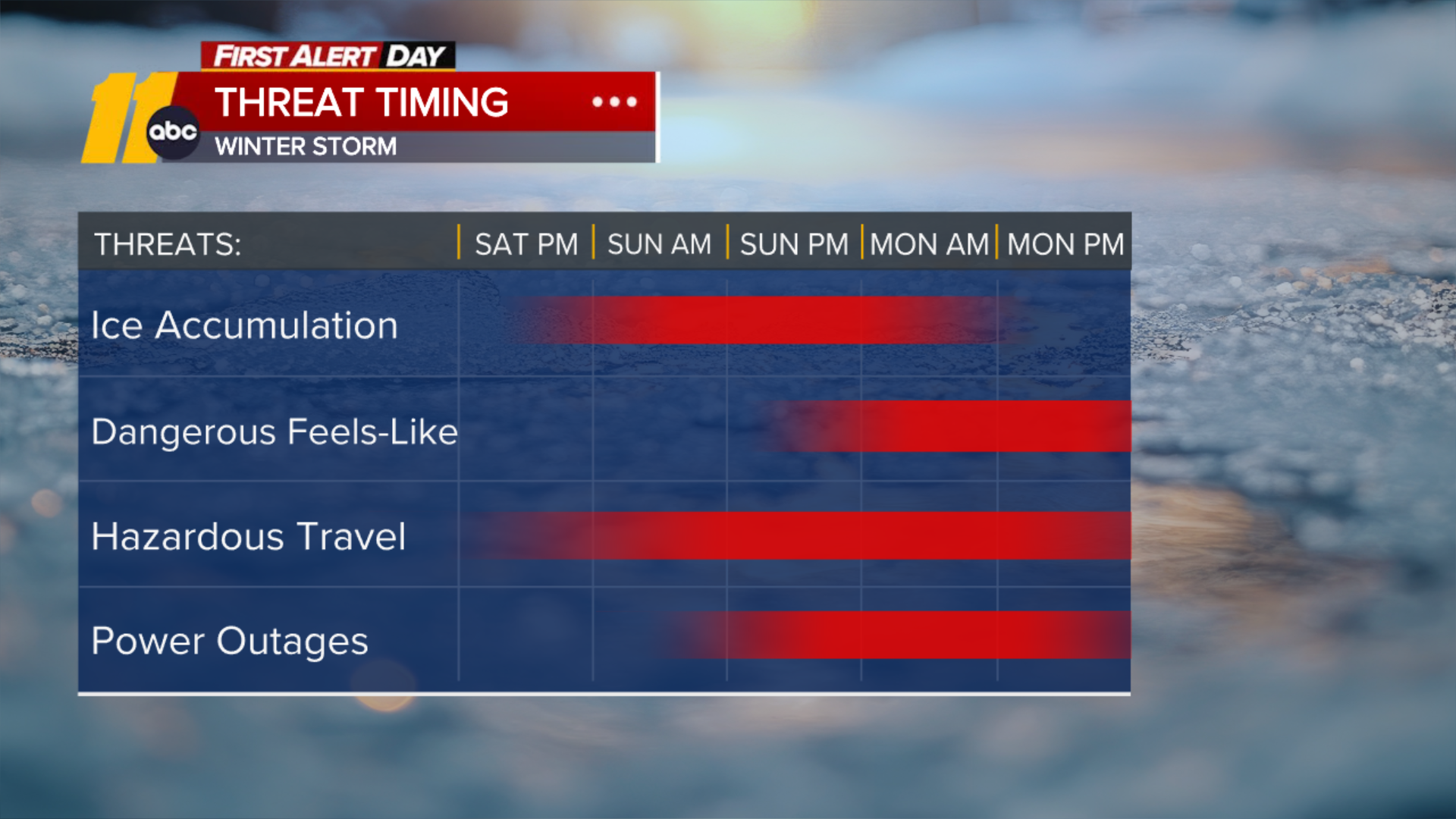
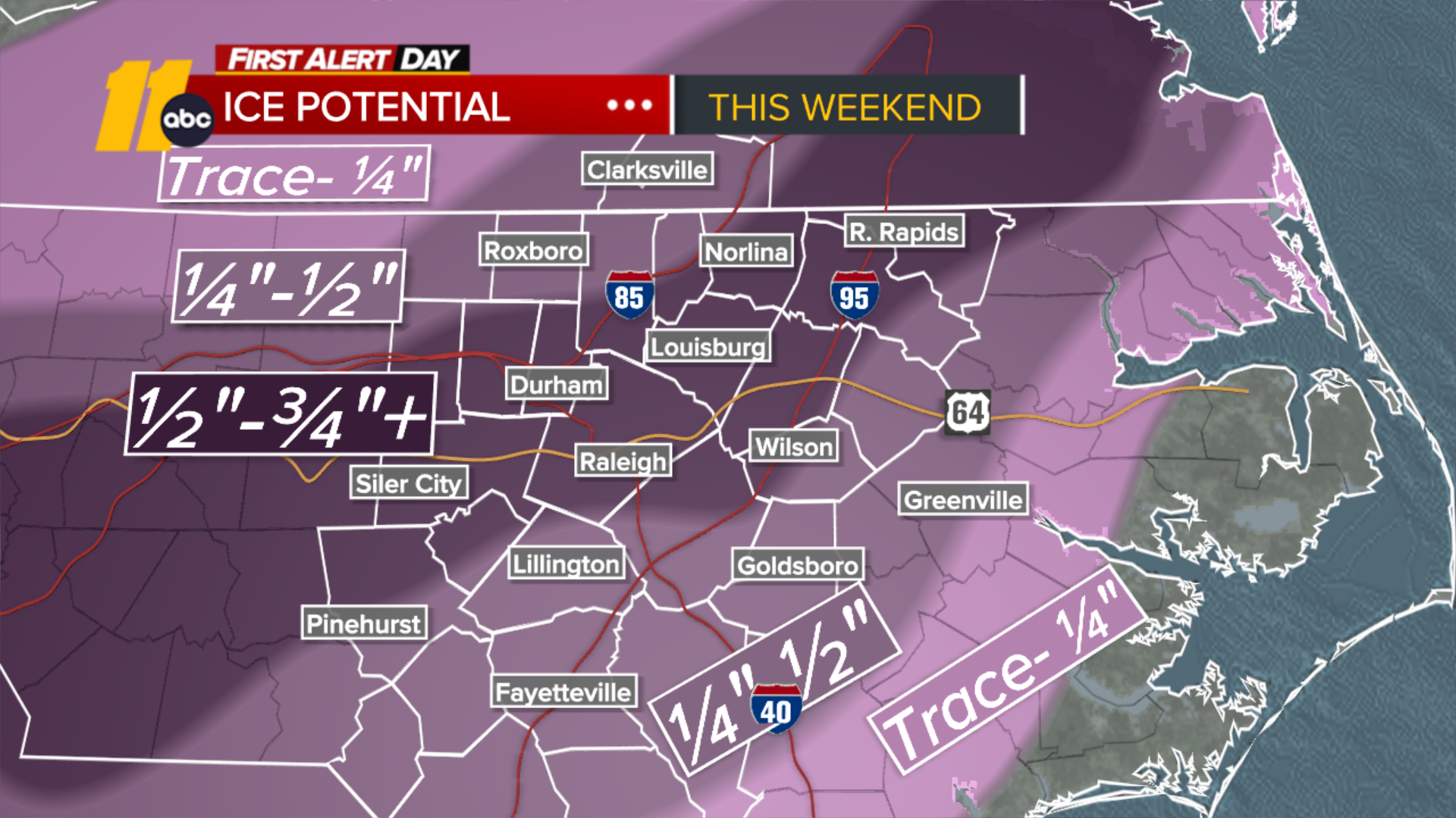
The winter weather is shifting its timeline slightly, with the arrival of precipitation now expected closer to 5 p.m. on Saturday. The forecast calls for snow and sleet to start Saturday evening, transitioning to sleet and freezing rain late Saturday night and continuing through Sunday evening.
Snowfall totals are likely to stay on the lower end of the 1 to 3-inch range, while sleet accumulations over half an inch are becoming more probable. Freezing rain, however, is expected to be the main concern, with ice accumulations of 0.25 to 0.75 inches possible in many areas.
Temperatures are not forecasted to rise above freezing until Monday, so that will be the first opportunity for any melting. But with low temperatures dropping well below freezing each night next week, any daytime melting could refreeze overnight, potentially creating travel challenges.
The arctic air will also bring unusually low high temperatures in the upper 20s to near 30 on Saturday. This could approach or even break records, with Saturday's record at 27 (set in 2014) and Sunday's at 28 (set in 2013).
Record-breaking cold possible
The Arctic cold invasion that will feed this winter storm arrives in the Midwest and Plains Thursday into Friday and will then spread into the South and East this weekend, locking in any snow or ice impacts and delaying recovery. Dozens of locations could break daily high and low cold temperature records, especially this weekend into early next week.
Temperatures will be more than 30 degrees below average by Friday in much of the Midwest and Plains. That's significant since mid- to late January is when average temperatures are already at their lowest level for many locations east of the Rockies.
Public schools in Chicago and Des Moines, Iowa, have canceled classes and activities Friday due to the dangerous wind chills, which could reach minus-35 degrees and minus-29 degrees, respectively.
The worst of the cold will push into parts of the South while spreading into the Northeast on Saturday, plunging thermometers as much as 20 to 40 degrees below average.
Dallas-Fort Worth could break record lows Sunday and Monday morning, possibly bottoming out in the single digits Monday. Shreveport, Louisiana, could do the same Monday and Tuesday morning as lows drop into the teens.
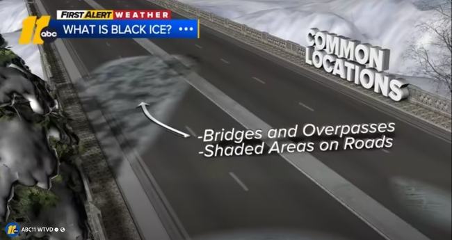
Black Ice Explained
CNN and Associated Press contributed to this report.