Storm chances increase to end the week

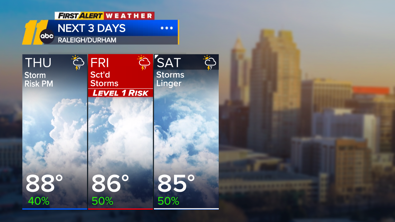
RALEIGH, N.C. (WTVD) -- First Alert Day-Friday: There is a Level 1 of 5 risk of isolated strong to severe storms Friday, with damaging winds as the primary threat. Thunderstorms on Friday also have potential to bring periods of heavy rain, which could lead to a risk of localized flooding.
It will be a very warm and muggy evening across the region. Lows tonight will only drop to around 70 degrees.
Thursday will feature an isolated storm threat during the afternoon and evening hours. Highs will top out in the mid to upper 80s.
With Friday's storms, there will be a risk for isolated damaging wind gusts and downpours as storms get going in the afternoon and linger through the evening.
Given this unsettled pattern, thunderstorms could train over the same areas, increasing the risk for flash flooding where repeated heavy downpours occur. There is also the risk that a front stalls for the first half of the weekend. The highest coverage in terms of precipitation looks like it will be Friday and Saturday.
By Sunday, the front will have pushed to our south. Dry weather returns to end the weekend, and temperatures will rise to near 90 degrees as a result.
Humid conditions will continue with afternoon high temperatures at least slightly above the historical average through the end of August.
Above-normal temperatures likely to end August and persist into early September, with highs in the low to mid 90s and feels-like temps around 100 to 105.
Tropics: For the North Atlantic...Caribbean Sea and the Gulf:
1. Eastern Tropical Atlantic (AL96):
An area of low pressure associated with a tropical wave, located a
few hundred miles south-southwest of the Cabo Verde Islands, is
producing showers and thunderstorms that are displaced to the
southwest of its center. Environmental conditions remain somewhat
favorable for development over the next couple of days, and a
tropical depression is likely to form over the next day or two as
the system moves westward to west-northwestward across the eastern
and central tropical Atlantic. Environmental conditions are forecast
to become less favorable by this weekend, potentially ending its
chances for development.
* Formation chance through 48 hours...high...60 percent.
* Formation chance through 7 days...high...60 percent.
Have a great night!
Cruz Medina