Flood Watch in effect through Friday as rounds of storms target central NC

RALEIGH, N.C. (WTVD) -- First Alert Day-Flood Watch: A Flood Watch has been issued for Central NC from today through Thursday/Friday morning. Rounds of showers and storms with a cold front will result in locally heavy rain, which may lead to flash flooding. Rain totals of 2 to 4 inches will be possible, with isolated higher amounts of 5-6+ inches.
First Alert-Severe Risk: Additionally, there is a Slight risk (level 2 of 5) of severe thunderstorms north of Raleigh. Damaging wind gusts or even a brief tornado will be possible this afternoon through tonight. There is a Marginal risk (Level 1 of 5) of severe thunderstorms for Raleigh and points south.
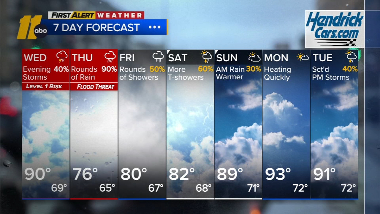
Good Wednesday morning! It's a super warm start, with out-the-door temps in the 80s for most. Highs will be near 90 in the Triangle, and mid 90s in the Sandhills. With better rain potential north during the day today, highs will be near 80.
The active stretch of weather continues today, with flooding downpours and damaging wind gusts remaining the primary threats. An isolated tornado is also possible. As the front finally moves through, thunderstorm coverage could be greater on Wednesday. Another front moves closer later in the week, so this'll keep conditions unsettled right through the weekend.
The slow-moving cold front across the NC will settle south and stall across the southern Carolinas Friday and into the weekend. This will shift the area of widespread rain south, with rain intensity decreasing on Friday and especially Saturday.
Drier weather is expected to return on Sunday, with fewer thunderstorms and increasing opportunities for sunshine. Temperatures will respond accordingly, rising into the upper 80s. Monday currently appears to be the driest day of the extended forecast, though as always in the summer, a spotty afternoon thunderstorm cannot be ruled out. Looking farther ahead, temperatures should continue climbing early next week, likely returning to the lower 90s by Tuesday as the front finally lifts away and summerlike heat begins to rebuild.
Tropics-Gulf of Mexico: On the forecast track, Bertha will move near or along the northern Gulf Coast during the next couple of days. Maximum sustained winds are near 50 mph (85 km/h) with higher gusts. Gradual weakening is forecast to continue over the next several days.
Key Messages:
1. Tropical storm conditions are expected to continue along portions of the northern Gulf Coast from the western Florida Panhandle to southeastern Louisiana, including the Metro New Orleans area, through tonight. Tropical storm conditions are possible for portions of the southwestern coast of Louisiana tonight into Thursday.
2. A Coastal Flood Warning is in effect for the Mississippi and Louisiana coastlines, where moderate coastal flooding is expected.
3. Interests elsewhere in extreme western Louisiana and along the Upper Texas Coast should monitor the progress of this system, as additional watches or warnings could be required for portions of that area later today.
4. Isolated areas of flash flooding remain possible through early Friday along the central to the western Gulf Coast from western Florida to southern Texas.
Have a great day!
Kweilyn