First Alert Day Today: Severe storms possible


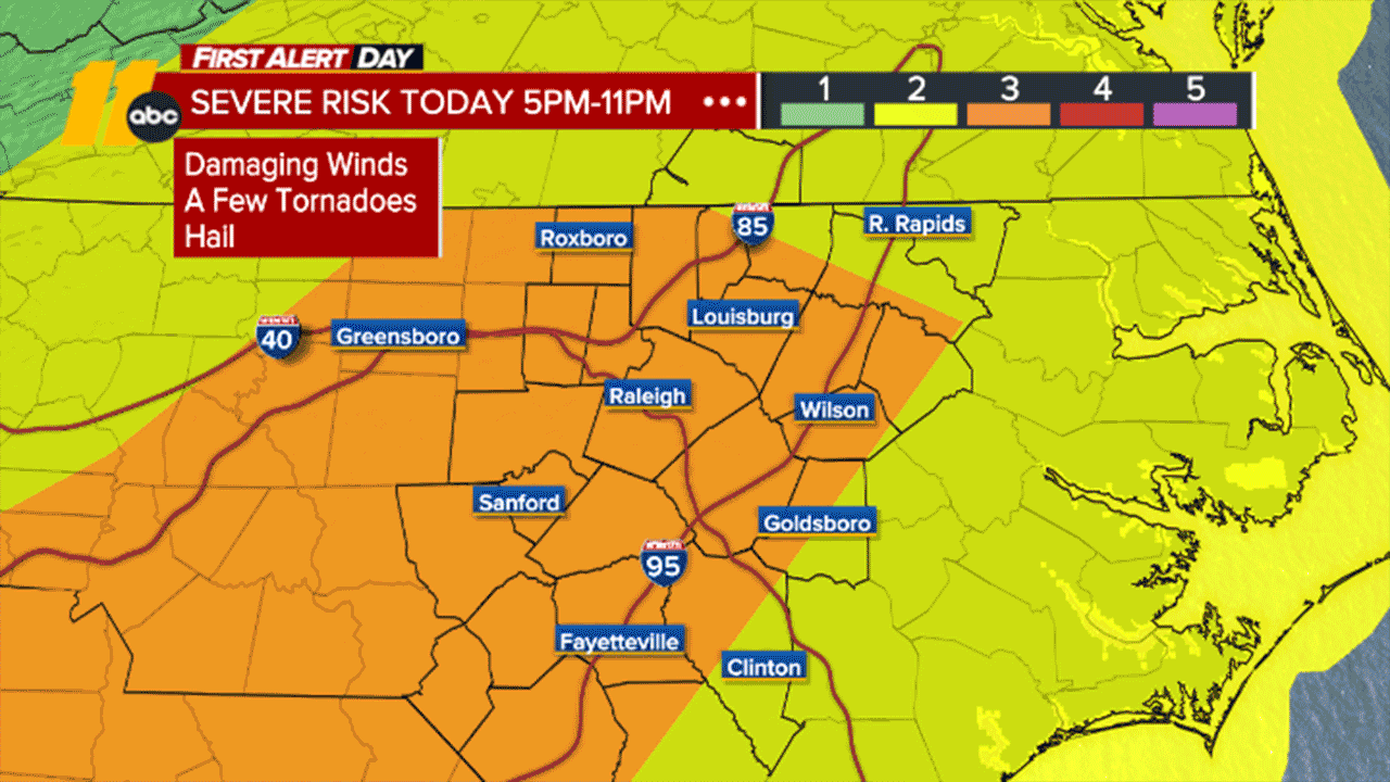
RALEIGH, N.C. (WTVD) -- First Alert Day Today: A cold front will move through Central NC this evening and tonight. Scattered showers and storms will develop into evening along and ahead of the front. The severe window will be from 5pm to 11pm as storms work through west to east. Within the strongest storms, strong to localized damaging wind gusts are the main concern, though hail to dime size and an isolated tornado or two are also possible. Rain Totals: 1" or less for most.
Good morning! There are plenty of clouds across the area this morning, as we watch a line of strong thunderstorms track across the Ohio and Tennessee Valleys, ahead of an approaching cold front.
Outside of passing showers this morning, conditions will be dry through much of the day with highs in the low 80s. Damaging wind gusts, hail and even an isolated tornado or two will be possible as these thunderstorms pass through.
Behind the cold front, temperatures tonight will fall lower than recent nights, dropping into the mid 40s to mid 50s.
The cooler conditions will continue into Tuesday as highs pressure settles over the region. As such, we should end up with a good bit of sunshine and dry weather.
More clouds should move in on Wednesday, as our attention turns toward the next big storm over the center of the nation. As we get more into a southerly flow, temps will climb into the mid 70s Wednesday. Highs Thursday will be in the mid 80s. By Friday, highs will be near 90 (record high is 88). Friday could very well end up being our first 90-degree day of the year. These temperatures will be closely monitored as we go through the week.
A spotty shower or thunderstorm may develop Thursday. Otherwise, models suggest the frontal boundary associated with this system will stall well to the north of the area, which may end up keeping us dry for the end of the week.
Things become a bit messier going to the weekend, as the low finally starts to shift eastward again and this boundary falls farther south, which may increase our thunderstorms chances again Saturday and especially Sunday and Monday.
After this, cooler conditions look to arrive behind this system next week.
Have a great day!
Kweilyn