Cooler weekend

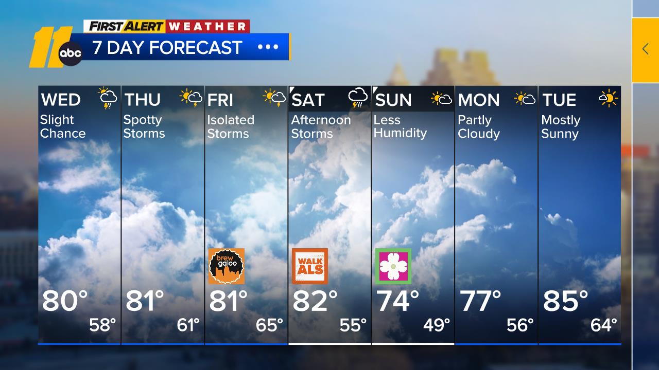
RALEIGH, N.C. (WTVD) -- Good morning! Our stretch of 80s continues today, with highs in the low 80s-that's almost 15 degrees above normal for this time of year. Clouds will increase throughout today as a weak cold front moves closer. Expect a slight cooldown this weekend.
WARM AGAIN: Morning temps are in the upper 50s to mid 60s. As a matter of fact, it's possible that we break a record-high low temp at RDU this morning, which is 63 degrees. We'll likely fall a bit short of record highs this afternoon.
NEXT COLD FRONT: A cold front to our west will cross the area Friday night into Sat AM. Thus, there is only a slight chance (20%) of a shower Friday night/early Sat AM.
THE WEEKEND: It'll turn cooler/seasonable behind the front this weekend as high pressure builds in behind the front. Highs will be in the upper 60s and low 70s, with lows in the upper 40s to low 50s.
ELECTION DAY: High pressure will build in and sit off the Southeast coast early next week. This will promote continued dry weather favorable weather for Election Day across the southeast US. Morning temps Tuesday will be in the upper 50s across Central NC. Highs will be near 80.
DRY OCTOBER: While our wet September prevented immediate drought concerns this month, some minor drought has begun expanding in central North Carolina and any rain would be beneficial in alleviating those concerns.
Tropics:
1. Southwestern Caribbean Sea: A broad area of low pressure is likely to develop over the southwestern Caribbean Sea during the next day or so. Gradual development is possible thereafter, and a tropical depression could form late this weekend or early next week while the system drifts
generally northward or northwestward over the central or western Caribbean Sea. Regardless of development, locally heavy rains are possible over portions of the adjacent land areas of the western
Caribbean.
* Formation chance through 48 hours...low...30 percent.
* Formation chance through 7 days...medium...60 percent.
2. Northeastern Caribbean Sea and Greater Antilles: Surface observations and satellite-derived winds indicate that a trough of low pressure located near Puerto Rico is producing widespread cloudiness and showers over the Dominican Republic, Puerto Rico, the Virgin Islands, the northern Leeward Islands, and the adjacent waters of the Atlantic and the northeastern Caribbean. Slow development of this system is possible during the next 2 to 3 days as it moves west-northwestward near the Greater Antilles. After that time, this system is expected to be absorbed into the low pressure area over the Caribbean. Regardless of development, locally heavy rains are possible during the next several days from the northern Leeward Islands westward across Puerto Rico and Hispaniola to eastern Cuba and the southeastern Bahamas.
* Formation chance through 48 hours...low...10 percent.
* Formation chance through 7 days...low...10 percent.
3. North Atlantic: A storm-force non-tropical low pressure area located about 450 miles west of the western Azores is producing limited shower activity. Some subtropical development is possible while the low moves generally eastward during the next few days. Additional information on this system is available in High Seas Forecasts issued by the National Weather Service.
* Formation chance through 48 hours...low...20 percent.
* Formation chance through 7 days...low...20 percent.
Have a great day!
Kweilyn


