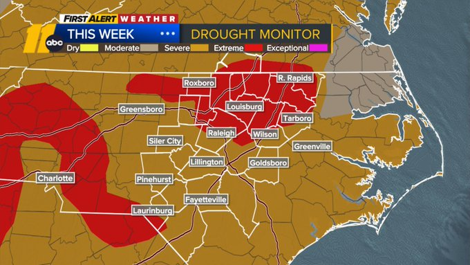
Drought conditions worsen in Central NC, rain possible this weekend


RALEIGH, N.C. (WTVD) -- First Alert: A warming trend continues with highs in the 80s through Saturday. Drought and fire concerns continue. Rain chances increase this weekend with the next cold front.
Good Thursday morning! High pressure remains offshore, leading to another mild start. Out-the-door temps are in the 50s for most under mainly clear skies. High pressure will continue to strengthen, leading to highs in the mid/upper 80s today. Highs will be in the upper 80s to around 90 by Friday and Saturday.
It'll be a bit less windy today compared to yesterday, with flow out of the west. The fire risk will be lower today, but given the lack of rainfall and ongoing drought, the burn ban continues until further notice.
Skies will be mostly sunny today and Friday. Clouds will increase Saturday ahead of the next cold front approaches. Rain and isolated storm chances will increase late Saturday afternoon through Saturday evening and night. Storms should remain below severe parameters.
A few showers could linger into early Sunday morning, but the main story will be cooler air, with highs in the 70s behind the front. Clouds will linger Sunday and into Monday.
Monday's high will also remain near the average-topping out in the mid 70s with lows in the 50s.
Models are signaling a more progressive pattern next week, with would promote increased rain chances early next week. The Gulf and Atlantic would be more in play and this should mean cooler and wetter conditions for our region.
The next front will approach Tuesday, bringing the next shot of scattered showers and isolated storms. This could be the best chance for a soaking rain in over a month. While it will not be enough to eliminate the drought, it will be beneficial.
Highs will climb to around 80 next Wednesday. Another good chance at rain arrives Thursday.
Have a great day!
Kweilyn