Snowstorm leads to extreme cold, closed schools, businesses, travel dangers in NC | Live Updates

WTVD logo
Last updated: Wednesday, February 4, 2026 1:53AM GMT
Second round of winter weather in Central NC

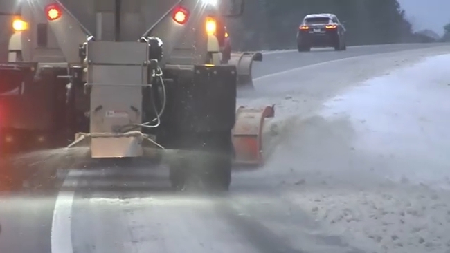
RALEIGH, N.C. (WTVD) -- Another winter storm, known as a bomb cyclone, hit parts of Central North Carolina for the second consecutive weekend.

Several weather alerts were issued for the ABC11 viewing area, including a winter storm warning and extreme cold warning. Heavy snow fell across the Triangle and much of North Carolina.

The National Weather Service office in Raleigh warned that wind chills will drop early Monday to near zero Fahrenheit (-17 Celsius). "Snow and ice will linger, with refreezing tonight making travel hazardous," the office said Sunday on social media. "Use caution on roads and dress in warm layers."

In eastern North Carolina, James City recorded 18 inches of snow, while Swansboro recorded 17 inches, the weather service reported.

The bomb cyclone, known to meteorologists as an intense, rapidly strengthening weather system, contributed to nearly a foot of snow in and around Charlotte. The snowfall represented a top-five snow event all-time there, the NWS said.

Flight cancellations exceeded 2,800 in the U.S. on Saturday, with at least another 1,800 on Sunday, according to FlightAware, a flight tracking and data company. More than 800 of those Sunday cancellations were for flights departing from or arriving at Charlotte Douglas International Airport.

The storm caused an hours-long mess on Interstate 85 northeast of the city, after a crash left dozens of semitractors and other vehicles backed up into Saturday evening, according to the State Highway Patrol. More than 1,000 traffic collisions and two road deaths were reported, North Carolina Gov. Josh Stein said Sunday.

Last week's storm blanketed the area with ice and kept schools closed for most of the week. However, most schools had remote learning days. Business owners said they were hurt by the storm because they had to close early or couldn't open at all.

The Associated Press contributed

Feb 01, 2026, 7:19 PM GMT

Snow Day Monday | List of school closures, remote learning

North Carolina school districts are making the call for Monday due to the winter storm, temperatures and weather-related conditions.

REMOTE LEARNING

  • Cumberland County - Asynchronous
  • Harnett County
  • Hoke County
  • Johnston County
  • Wilson County

CLOSED

  • Lee County
  • Nash County
  • Northampton County
  • Wayne County

Check full list here for updates.

Download the ABC11 App for breaking news alerts and weather alerts

Get live updates from ABC11 throughout the storm online, where you stream and in our live blog.

WTVD logo
Feb 01, 2026, 5:46 PM GMT

Durham Fire Department battles snowfall and crashes

The Durham Fire Department responded to multiple vehicle crashes overnight as about four inches of snow accumulated at Station 1 on East Morgan Street.

Crews are working to clear primary and bridge routes, with rescue and ladder trucks upstaffed for response. Scene support vehicles include a driver focused on safe travel while another strategizes call response. Additionally, crews are assigned to clear driveways for fire and police.

Authorities urge residents to stay inside if they don't need to be out and to remain aware of their surroundings.

Our Akilah Davis has more:

Our Akilah Davis has more.
WTVD logo
Feb 01, 2026, 5:04 PM GMT

Stein urges caution on roads, warns of dangerously cold temps

Governor Josh Stein shared updates Sunday on North Carolina's response to this weekend's snowstorm, emphasizing ongoing road hazards.

"While the storm has passed, the snow remains and our roads will remain dicey in the days ahead," he said. "Please continue to avoid unnecessary travel and use caution if you must drive."

Snow in eastern North Carolina is expected to end by mid-morning, with dry conditions following. However, gusty winds up to 25-30 mph are forecast statewide, with stronger gusts of 55-60 mph along the coast and 40-55 mph in the mountains. Highs will only reach the 20s and 30s, with wind chills in the single digits to teens.

Coastal flooding and ocean overwash are also possible, with portions of NC Highway 12 potentially impassable at high tide.

State officials urged residents to stay off roads to allow first responders and NCDOT crews to work safely. Over 2,500 NCDOT employees and contractors have been clearing roads since Saturday, spreading over 15,000 tons of salt and prioritizing interstates and major highways. However, snow-clearing efforts are expected to take several days due to persistent cold temperatures.

Watch full press conference

WTVD logo
Feb 01, 2026, 3:20 PM GMT

Duke Energy urges customers to reduce energy use Monday

Duke Energy is urging customers to help ease the strain on the electric grid by reducing energy use Monday morning between 4 and 10 a.m. This move aims to lower demand and avoid the need for temporary power outages.

Here's how you can pitch in:

  • Set your thermostat to the lowest comfortable level.
  • Hold off on using major appliances like washers, dryers, and dishwashers during that time.
  • Switch off unnecessary devices, unused plug-ins, and lights.
  • If you own an electric vehicle, charge it midday when demand is lower.

"We know it's inconvenient to reduce electric use, but it makes a real difference." said Gerald Wilson, Duke Energy vice president of grid operations. "We are taking every step to meet our customers energy needs, including maximizing our generation and purchasing power and working with large commercial and industrial customers who have demand response programs. We appreciate our customers' cooperation, patience and understanding as we work to maintain reliable service across the Carolinas."