NC coastal flood warning, high surf advisory in effect along parts of Outer Banks: Tracking Imelda

WTVD logo
Last updated: Sunday, October 5, 2025 3:20PM GMT
First Alert Noon Weather: October 2

Imelda strengthened into a hurricane Tuesday morning.

The storm is on track to move away from the Bahamas and approach Bermuda late Wednesday and early Thursday.

Imelda is expected to approach the U.S. Southeast coast on Tuesday. Due to no landfall expected, the flooding threat is now lower.

On Saturday, North Carolina Gov. Josh Stein declared a state of emergency ahead of the possible heavy rain and flooding.

ByDÁNICA COTO AP logo
Sep 30, 2025, 11:02 AM GMT

Here's the latest path of Imelda, forecast to become hurricane Tuesday

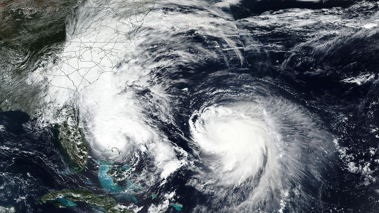
Imelda had maximum sustained winds of 70 mph (110 kph) and was moving northeast at 7 mph (11 kph). It was forecast to become a hurricane on Tuesday morning and spin out to open ocean, according to the National Hurricane Center in Miami.

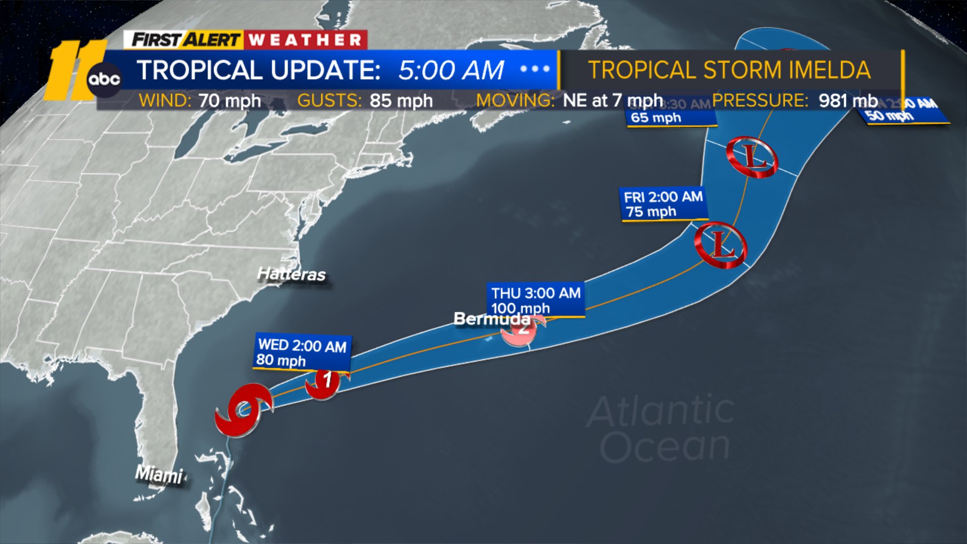
Meanwhile, Hurricane Humberto, which weakened further to a Category 2 storm on Tuesday, churned in open waters, which forecasters had said would cause Imelda to abruptly turn to the east-northeast, away from the southeastern United States coast.

"This is really what's going to be saving the United States from really seeing catastrophic rainfall," said Alex DaSilva, lead hurricane expert for AccuWeather, a private U.S. weather forecasting company.

WTVD logo
Sep 30, 2025, 3:21 AM GMT

11 p.m. update on Imelda as storm strengthens

We're keeping an eye on Tropical Storm Imelda.

At the National Hurricane Center's 11 p.m. update, the storm was still off the coast of Florida with 65 mph sustained winds, the same measure as in the 8 p.m. update. The storm slowed slightly from three hours earlier and was moving north at 8 mph, down from 9 mph. It's wind gusts maxed out at 70 mph.

This satellite image taken by NASA on Monday shows Tropical Storm Imelda, left, and Hurricane Humberto in the Atlantic Ocean.

Imelda is still expected to intensify into a hurricane on Tuesday, and its track continues to suggest that it will move further away from the continental United States.

However, it is expected to approach Bermuda on Wednesday as a hurricane, and a Hurricane Watch is in effect for that island.

Swells and rough surf are expected to affect the US coast from both Hurricane Humberto and Imelda in the next several days.

Humberto had weakened to a Category 3 hurricane at 11 p.m., with top winds of 115 mph, down from 1440 mph earlier in the day. Though it's still tracking away from land, Humberto, coupled with Imelda, is capable of producing high surf and dangerous rip currents along the East Coast.

WTVD logo
Sep 29, 2025, 8:41 PM GMT

Expected Imelda impacts along NC coastal areas

The main impacts from Imelda will likely be strong, persistent NE wind along the Outer Banks, which could lead to some coastal flooding and erosion.

Farther to the southeast, we are now forecasting 2-4 inches of rain around Wilmington and Myrtle Beach, which may even end up on the lower end of that range due to the southward shift in Imelda's track.
And as Imelda churns in the Atlantic -- officials are warning of dangerous rip currents, surfing, beach erosion and coastal flooding.

Elaina Athans Image
Sep 29, 2025, 10:40 PM GMT

Wrightsville Beach preps for rough surf, possible flooding

People in Wrightsville Beach are keeping an eye on Tropical Storm Imelda and staying prepared.

No evacuation orders are expected, since Imelda is forecast to make a sharp turn and head out to sea.

In the meantime, surfers in Wrightsville Beach are taking advantage of the high surf as the tropical storm churns in the Atlantic Ocean.

People in Wrightsville Beach are preparing for the possible effects of Tropical Storm Imelda.

The storm hammered the Bahamas during the weekend with strong winds and heavy rains. It's now moving north off Florida's east coast, not far from another storm, Hurricane Humberto.

"The combined impact of the two storms, Humberto and Imelda, may cause isolated flash flooding, coastal flooding, ocean overwash, wind gusts, and dangerous currents throughout much of this week," NC Gov. Josh Stein said Monday. "Last Saturday's one-year milestone of Hurricane Helene reminds us the importance of being prepared."

Coastal cities face the potential for flash flooding with heavy rain in the forecast.

In Wake County, the emergency management department handed out free preparedness kits.

"There's a flashlight in here, there's a first aid kit, information about how to prepare, what else you might need as an individual," said Josh Creighton, of Wake County Emergency Management. "There's information on pets, on how to keep them safe during an emergency, what you may need to bring to a shelter."