NC coastal flood warning, high surf advisory in effect along parts of Outer Banks: Tracking Imelda
Last updated: Sunday, October 5, 2025 3:20PM GMT
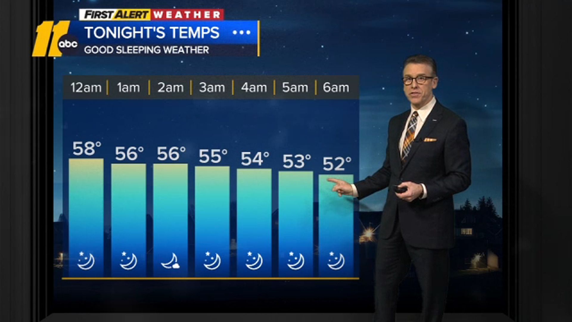
Rain chances return at the beginning of next week.
Imelda strengthened into a hurricane Tuesday morning.
The storm is on track to move away from the Bahamas and approach Bermuda late Wednesday and early Thursday.
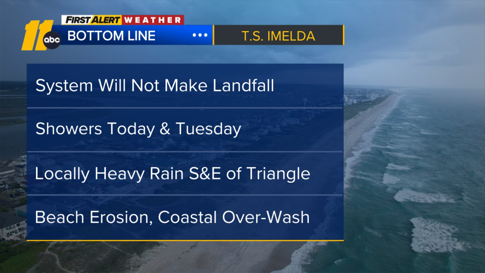
Imelda is expected to approach the U.S. Southeast coast on Tuesday. Due to no landfall expected, the flooding threat is now lower.
On Saturday, North Carolina Gov. Josh Stein declared a state of emergency ahead of the possible heavy rain and flooding.
Key Headlines
Oct 02, 2025, 5:06 PM GMT
Oct 02, 2025, 2:52 PM GMT
Oct 01, 2025, 5:16 PM GMT
Oct 01, 2025, 4:04 PM GMT
Sep 30, 2025, 10:14 PM GMT
Sep 30, 2025, 7:20 PM GMT
Sep 30, 2025, 6:23 PM GMT
Here's how the news is developing.
Sep 30, 2025, 6:23 PM GMT
Flood warning issued in Dare County: Imelda
Due to weather conditions caused by Hurricane Imelda, a Coastal Flood Warning has been issued for Dare County, beginning at 11 a.m. on Tuesday, until 8 p.m. on Friday.
In addition, a Wind Advisory is in effect beginning at 8 p.m. on Tuesday through 8 p.m. on Wednesday.
A High Surf Advisory remains in effect until 8 a.m. on Saturday.
Sep 30, 2025, 3:55 PM GMT
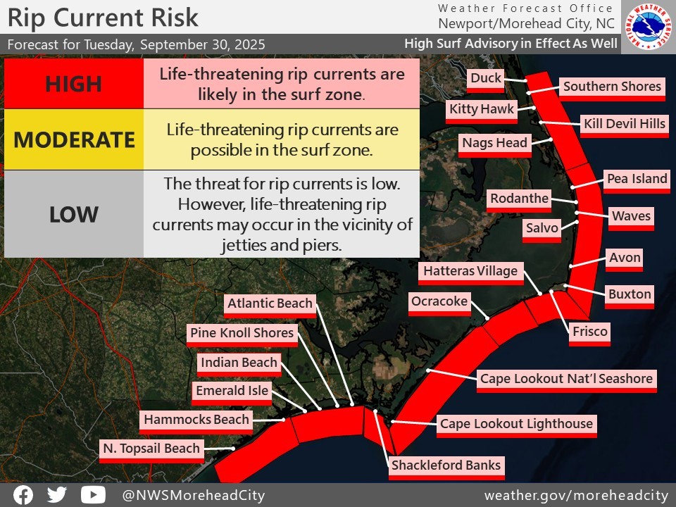
Red Flag Day at for NC Outer Banks
The National Weather Service office in Morehead City has issued a Red Flag Day due to high rip current risk.
The warning includes beaches from Duck to Ocracoke on the North Carolina Outer Banks.
NWS says ocean conditions will bring powerful rip currents and dangerous breaking waves, making swimming unsafe.
The strongest rip currents often occur a couple of hours either side of low tide.
Sep 30, 2025, 3:10 PM GMT
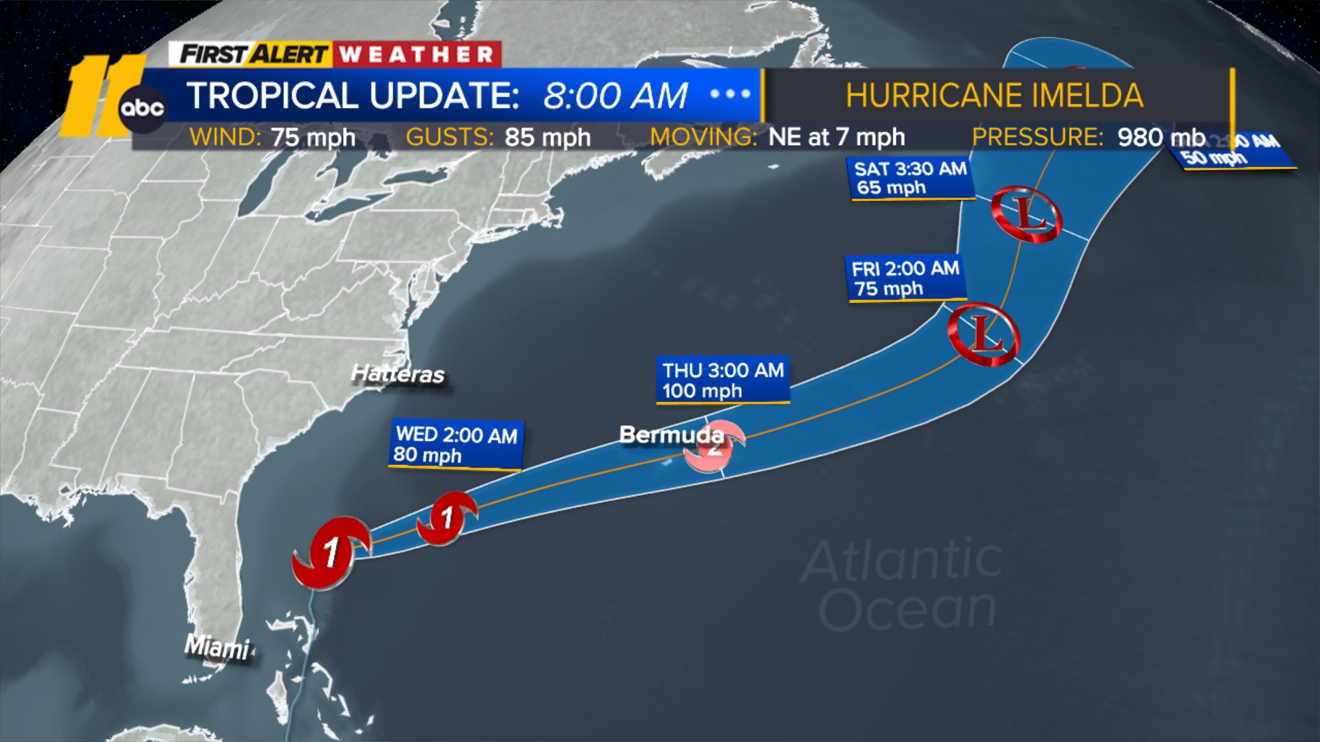
Imelda now a hurricane, still no landfall
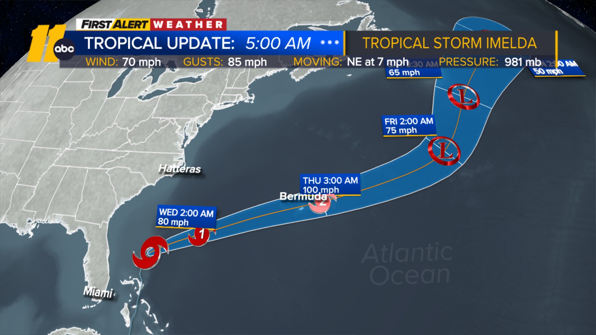
As of Tuesday 8 a.m., Imelda has strengthened into a Category 1 hurricane. It is on track to move away from the Bahamas and approach Bermuda late Wednesday and early Thursday.
Our Sean Coffey is down by the coast, while Tamara Scott is in the Triangle.
ByDÁNICA COTO 
Sep 30, 2025, 11:02 AM GMT
Here's the latest path of Imelda, forecast to become hurricane Tuesday
Imelda had maximum sustained winds of 70 mph (110 kph) and was moving northeast at 7 mph (11 kph). It was forecast to become a hurricane on Tuesday morning and spin out to open ocean, according to the National Hurricane Center in Miami.
Meanwhile, Hurricane Humberto, which weakened further to a Category 2 storm on Tuesday, churned in open waters, which forecasters had said would cause Imelda to abruptly turn to the east-northeast, away from the southeastern United States coast.
"This is really what's going to be saving the United States from really seeing catastrophic rainfall," said Alex DaSilva, lead hurricane expert for AccuWeather, a private U.S. weather forecasting company.