Tropical Storm Imelda to bring rain and wind in Carolinas this week, no landfall predicted


RALEIGH, N.C. (WTVD) -- See latest updates here.
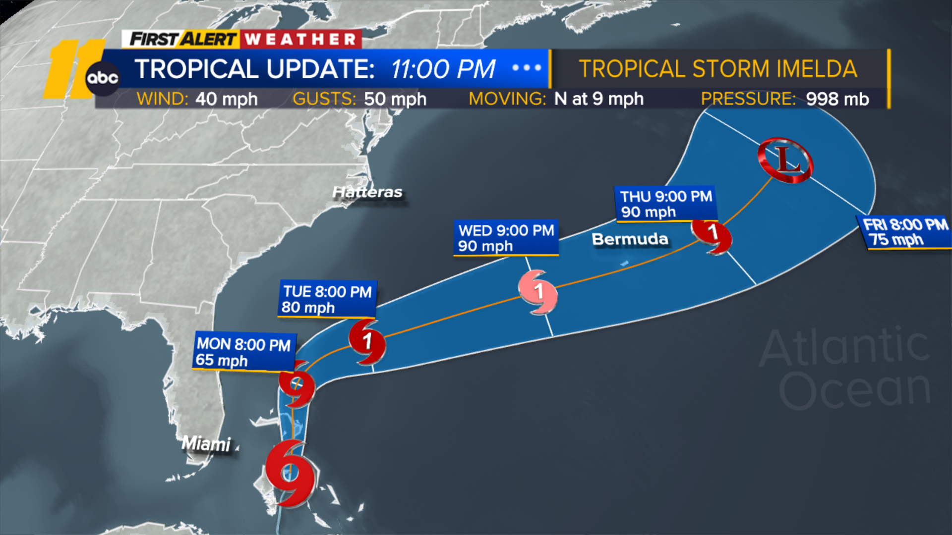
Tropical Depression Nine strengthened into Tropical Storm Imelda on Sunday in the Atlantic, and could bring storm surge and strong winds to the Southeast U.S. coastline this week.
As of Sunday at 11 p.m., the National Hurricane Center (NHC) reported the system had sustained maximum winds of 40 mph and was moving north at 9 mph.
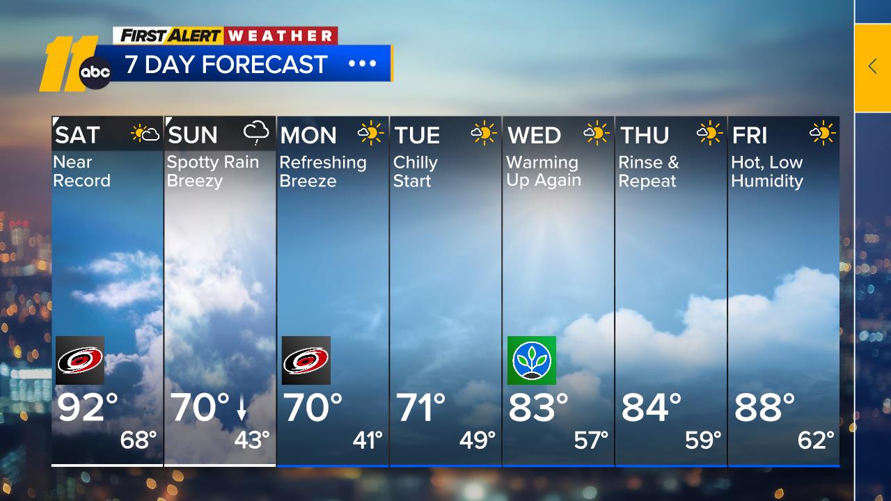
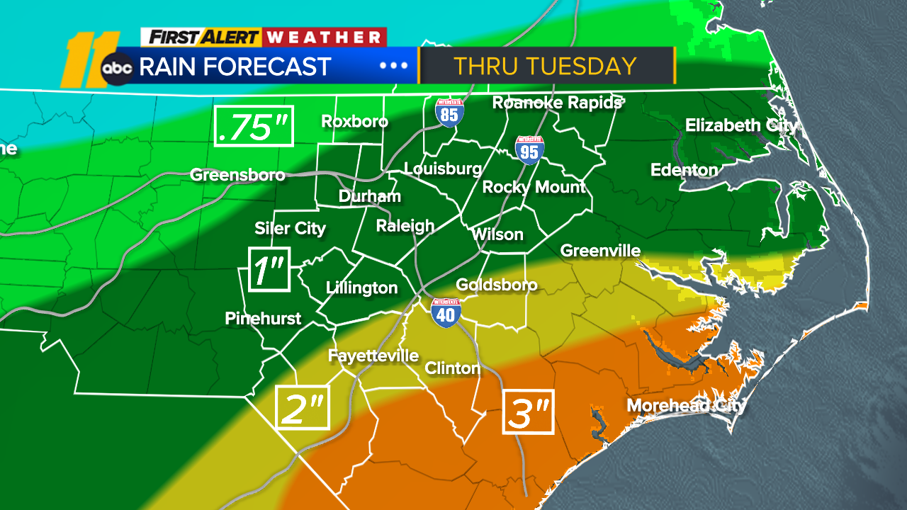
By Tuesday, it is expected to approach the Georgia and South Carolina coasts, potentially as a strong tropical storm or Category 1 hurricane. Due to no landfall expected, the flooding threat is now lower. That said, an isolated flood threat exists from the NC coast to the Triangle.
While the risk of significant wind impacts along the coast is decreasing, people should continue monitoring the latest forecast. Landfall is unlikely, but the coastline up to Virginia may experience indirect impacts, including rain, moderate wind gusts, and coastal flooding from prolonged onshore flow.
Governor Josh Stein has declared Saturday a State of Emergency for NC, preparing for the potential impacts.
"North Carolinians across the state should prepare for tropical weather to bring heavy rainfall and potential flooding," Stein said. "This State of Emergency will enable North Carolina's State Emergency Response Team to mobilize resources and prepare for potential impacts. Forecasts remain uncertain, so it's important that North Carolinians get prepared now, have emergency kits ready, and listen to local emergency guidance to stay safe and informed."
Stay on top of the latest weather updates by downloading the ABC11 app
ALSO SEE | How to prepare for a hurricane
Tracking the developing storm's path
Imelda is expected to move into more favorable conditions over the next 24 hours, the reason for its expected strengthening.
Sunday through Monday, Imelda will track north through the Bahamas and parallel to the east coast of Florida where it will batter the Bahamas with heavy rain and tropical-storm-force winds.
While there is still some uncertainty with the track because of a complex steering setup, weather models are beginning to align with the storm beginning to slow down as it approaches the coast of Georgia and South Carolina, then making a hard turn east and avoiding landfall. It may also get a helping "tug" from strong Hurricane Humberto well off to the east near Bermuda.
A State of Emergency was also declared in South Carolina, urging residents to monitor the forecast and prepare.
In an afternoon press conference, SC Governor Henry McMaster said the state has "no intention" of issuing any mandatory evacuation orders for the upcoming storm, but that people should not "be misled."
"We know that we're going to have high winds, we know that we're going to have a lot of water," the governor said.
McMaster also invoked the one-year anniversary of Hurricane Helene to compare it to the uncertainty of this storm.
"We remember that it did not go exactly where it was expected to go," McMaster said. "This storm does not look as strong as it looked yesterday, but that could change tonight."
The governor said he is "expecting" the federal government to cooperate with them, "100%," and that Friday's emergency declaration was to begin putting people and equipment in the right places, including helicopters and aerial resources.
"The good news is the storm will probably stay out in the ocean," McMaster said, while still cautioning people to be prepared. "Don't drive through standing water... we lose a lot of people through drowning," the governor said, calling that "pitiful."
What to know about Hurricane Humberto
Meanwhile, Hurricane Humberto has rapidly intensified to become the third major hurricane of the 2025 Atlantic hurricane season and the second Category 5 storm of the year. The NHC said Saturday that Humberto is expected to "remain a powerful major hurricane through early next week."
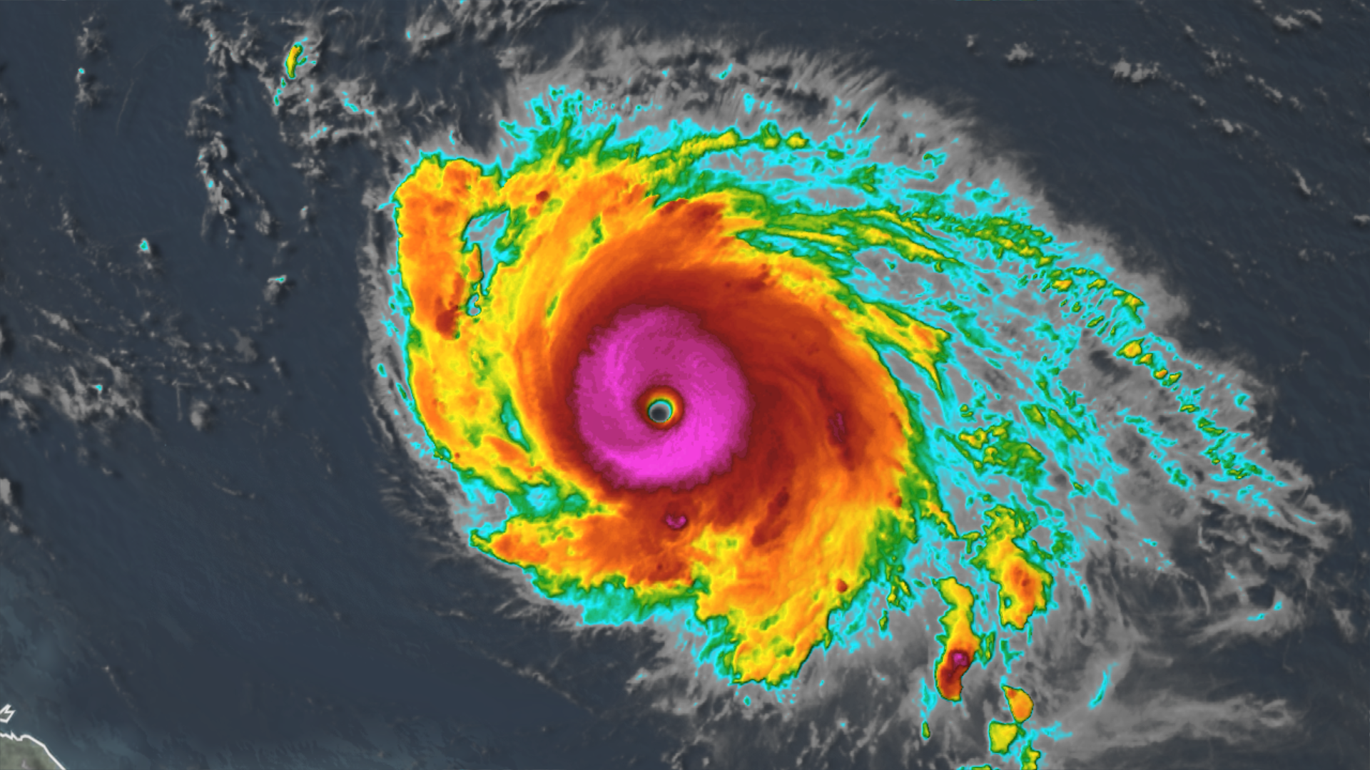
Humberto is still expected to track west of Bermuda on Tuesday through Wednesday and stay hundreds of miles west of the U.S., eventually turning northeast and back out to sea without a landfall.
It could also interact with Imelda and help pull the storm out to sea along with it.
ABC News' Kyle Reiman, David Brennan, and Nadine El-Bawab contributed to this report.
ALSO SEE | Types of generators: What to know about power generators before a blackout