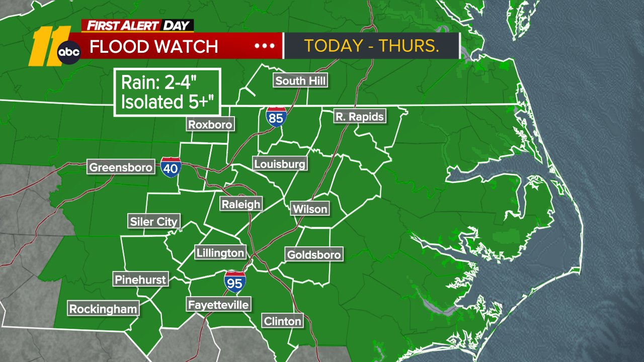
First Alert Weather: Triple-digit heat, storm threats into the weekend

WTVD logo
First Alert Morning Forecast: June 12

RALEIGH, N.C. (WTVD) -- First Alert-Dangerous to End the Week: The heat wave continues through the weekend, with the most intense heat developing today. High temps will range from 100 to 105 with feels-like temps of 100 to 109.

First Alert-Storm Risk: In addition, there is a slight risk (level 2 of 5) of severe storms late Friday through Friday night. The greatest threat will be damaging winds. Locally heavy downpours may lead to street flooding.

Good morning! Today will be another record-setting day with highs of 100 to 105. The current record at RDU is 98 degrees, set in 2002. Feels-like temps will soar towards 100 degrees.

A cold front will approach the area today, the same front that brought widespread severe weather to the Midwest yesterday and overnight. It will trigger isolated storms this afternoon and scattered evening storms. Storms that do develop could bring hail, damaging wind gusts, and quick downpours.

It will be hot yet again tomorrow, though a bit less humid behind the front tonight, so the heat will be less intense than today. A few storms will be possible Saturday, with the risk of strong winds and downpours.

Sunday will be another hot day, with highs approaching 100 degrees. Another front approaches on Sunday and will trigger more afternoon and evening thunderstorms. Thunderstorms on Sunday could bring flooding downpours and localized damaging wind gusts.

More scattered showers and storms will be possible Monday along the front as it continues southeastward. Highs will be near 90 Monday and less humid.

By Tuesday, temperatures will finally cool into the mid 80s. Lingering showers and storms will be possible with the front.

The next strong high builds over the region later next week, sending highs back into the mid 90s Thursday.

Tropics:
Bay of Campeche:
Disorganized showers and thunderstorms are occurring over the
Yucatan Peninsula and the adjacent Bay of Campeche, and a broad
area of low pressure is expected to form in this area later today.
Environmental conditions are forecast to be only marginally
conducive for development before the system moves inland over
eastern Mexico late Saturday or Sunday.
* Formation chance through 48 hours...low...10 percent.
* Formation chance through 7 days...low...10 percent.

Have a great day!
Kweilyn


Copyright © 2026 WTVD-TV. All Rights Reserved.