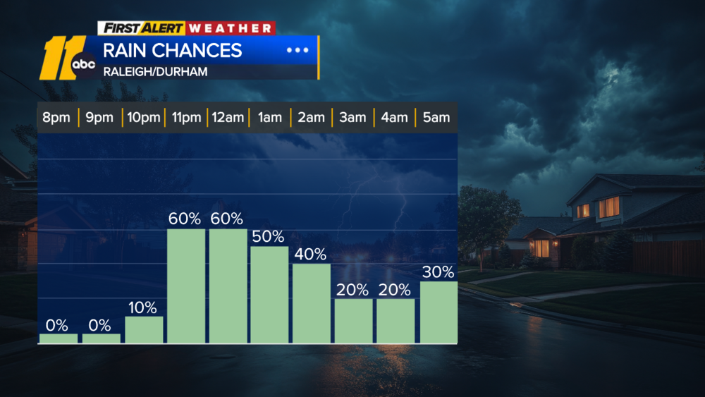
Erin is starting to turn away from the United States, but don't breathe a sigh of relief just yet: The massive hurricane is still churning up the Atlantic Ocean, keeping dangerous conditions in place for more than 1,000 miles of the East Coast.
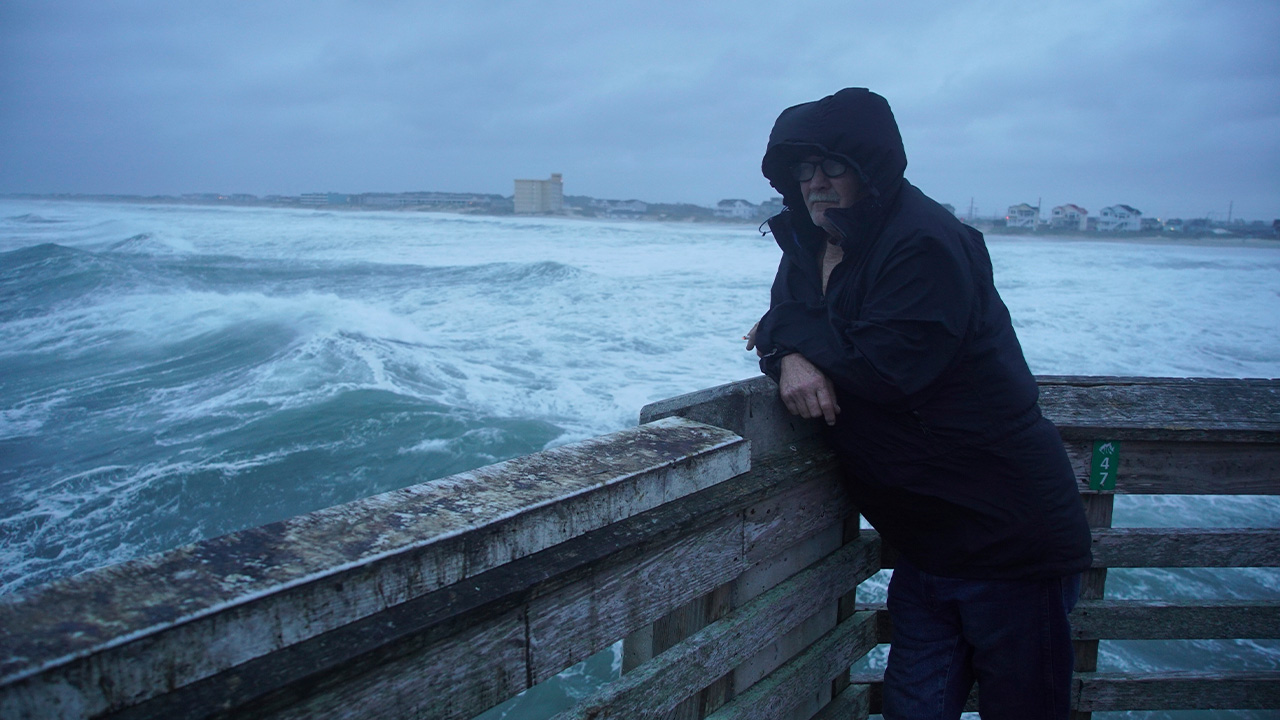
Hurricane Erin has been a major disruption for coastal communities this week - especially North Carolina's Outer Banks - even without making landfall. It's stirred up life-threatening rip currents that prompted dozens of rescues and sent rushing water and sand over island roads. Erin could keep pushing the ocean onto coastlines through at least Friday.
The hurricane made its closest approach to US soil on Wednesday night as it skirted just 200 miles from the Outer Banks. It brought serious coastal flooding that has eroded beaches and shut down parts of the highway linking the barrier islands.
Erin's northeast turn away from the US began early Thursday, and it's forecast to find its gas pedal soon and accelerate away from the coast.
Its tropical storm-force winds reached nearly 575 miles from end-to-end Thursday morning, making Erin larger than 90% of tropical systems that have roamed the same part of the Atlantic at a similar strength, according to the National Hurricane Center.
A myriad of marine warnings from the National Weather Service stretch from Florida to Maine on Thursday as Erin's huge reach roughs up seas.
Tropical storm warnings are no longer in effect in the US as of Thursday night. Erin delivered tropical storm-force wind gusts of 40 to 50 mph to much of the Outer Banks early Thursday morning and some 45 mph gusts to coastal Virginia and Maryland. A tropical storm warning remains in effect for Bermuda.
As Erin moves farther north, the hurricane is ramping up coastal flooding risks for other parts of the mid-Atlantic as well as the Northeast by driving water levels higher than they should be, especially at high tide. Flood waters have rushed into coastal areas from South Carolina all the way up the coast into New Jersey, New York, and Massachusetts.
The rip current risk also remains high through Friday for most of the East Coast. An elevated risk will likely persist at least through the weekend.
More than 70 people were rescued from rip currents in North Carolina this week, before Erin's closest pass.
"Some of these rips are pulling six to eight people out at a time," Wrightsville Beach ocean rescue director Sam Proffitt told CNN, describing the conditions as "very strong" and "dangerous." Proffitt noted the volume of water moving and funneling out is so intense, it "really doesn't matter how good of a swimmer you are."
North Carolina bore the brunt of Erin
North Carolina remains under a state of emergency after Erin sent large waves crashing into the coastline - impacting seaside homes and businesses - and spurred significant coastal flooding in its Outer Banks on Wednesday.
Evacuations were ordered ahead of the hurricane for parts of the Outer Banks, including the Hatteras and Ocracoke islands. The North Carolina Ferry System evacuated over 2,200 people and 1,100 cars from Ocracoke Island on Wednesday alone.
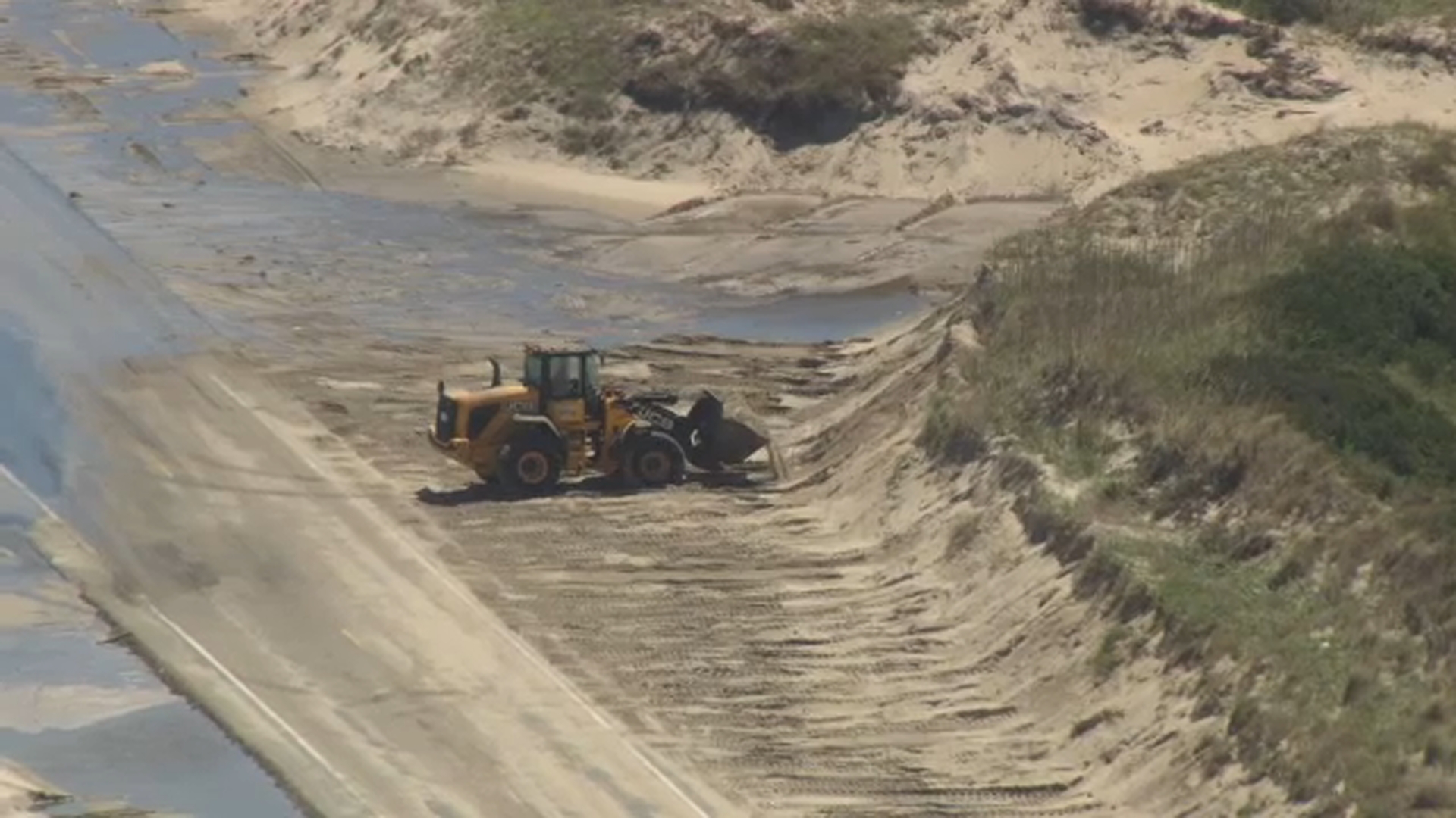
Officials had warned earlier in the week that the region's Highway 12 - the slim, scenic stretch of road connecting the barrier islands - could become completely inaccessible. They were correct.
Highway 12 was closed as of Thursday morning after sand, water, and debris covered sections of the roadway overnight. The force of the hurricane-whipped ocean breached and flattened sand dunes designed to protect the roadway in parts of Hatteras and Ocracoke, according to the North Carolina Department of Transportation.
Crews are working to clear the highway, but the transportation department had no estimate Thursday morning on when it would reopen.
Will Erin have a successor?
Erin will lose steam as it heads for the northern Atlantic and enters more hostile atmospheric conditions this weekend, and could be a tropical storm by Sunday - a far cry from the violent Category 5 hurricane it was for a time last weekend.
It became one of the fastest-rapidly intensifying storms in Atlantic history after it strengthened from a Category 1 to a Category 5 in just 24 hours. Hurricanes are rapidly intensifying more frequently as the oceans and atmosphere warm in a world polluted by fossil fuels.
Odds are Erin won't be the last rapidly intensifying Atlantic hurricane of the season - last year had nine.
The next few days could see more tropical systems develop in Erin's wake.
An area of showers and thunderstorms near the Caribbean's Leeward Islands has a high chance of forming into at least a tropical depression this weekend, according to the NHC. Where it goes from there isn't clear, but early indications are it may take a curve similar to Erin.
Another area of stormy weather over the open tropical Atlantic has a medium chance to develop into a short-lived tropical depression by the end of the week.
The-CNN-Wire
& 2025 Cable News Network, Inc., a Warner Bros. Discovery Company. All rights reserved.