Severe risk passes, nicer weather weekend ahead

RALEIGH, N.C. (WTVD) -- Central North Carolina avoided any significant severe weather Thursday.
Isolated afternoon thunderstorms were possible as a front moved through the region, but the storm system lost energy after hitting the Charlotte area hard.
Weather turns deadly in western NC
A state of emergency was declared for Gaston County on Wednesday evening following a large storm.

First responders were working to clear roads of downed power lines and broken trees and were helping residents, officials said.
The New Hope Fire Department responded to a tree down on a car. One person in the car was killed and another was taken to a hospital, officials said.
More than 135,000 customers had lost power in the state as of Wednesday evening, according to PowerOutage.us.
Gaston County Schools announced Wednesday night that there would be no school for students on Thursday.
Looking ahead
By Friday, a cold front will move into central North Carolina and bring cooler conditions with a mix of clouds, sunshine and cooler air. Most of the thunderstorms and showers should stay south of the Triangle.
On Friday, temperatures will be in the upper 70s, and there will be enough instability to trigger a few showers late in the day.
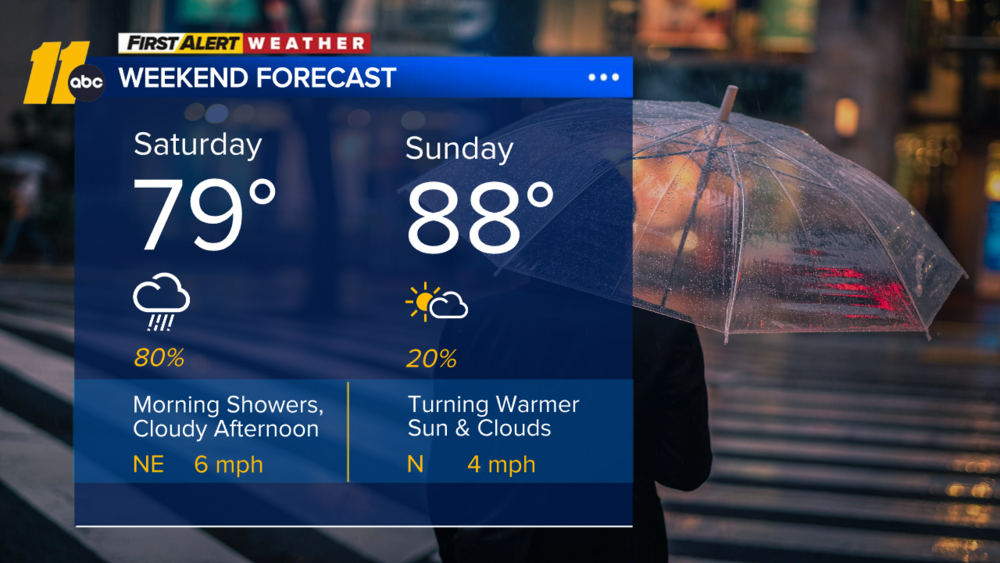
The good news is that Mother's Day weekend looks to be setting up nicely weather-wise. We clear out for the weekend with temperatures in the mid-70s on Saturday and Sunday.
The Associated Press contributed.