A warm and unsettled week ahead


RALEIGH, N.C. (WTVD) -- First Alert-Unsettled Week: A stalled/slow-moving cold front will trigger chances for showers and storms Tuesday through Friday. The wettest days will be Tuesday and Wednesday. Tuesday is a First Alert Day for the risk of an isolated severe storm in the afternoon & evening. Temps will remain above average this week.
This afternoon will feature highs in the mid-80s and a partly cloudy sky. Clouds will continue to increase tonight ahead of an approaching cold front.
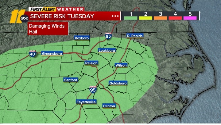
The front is expected to move to the center of the state tomorrow, which will spark a couple thunderstorms in the afternoon and evening. There is a Level 1 of 5 severe risk Tuesday afternoon & evening. An isolated damaging wind gust and hail will be possible.
Highs Wednesday will be in the mid/upper 70s. The front is not expected to move farther south, which will allow for another risk of thunderstorms across the viewing area. As the front remains nearby Thursday and Friday, the risk for showers and storms will linger.
While temperatures will remain above normal through the week, the daily rain chances and considerable cloud cover will help keep highs slightly tempered and support mild/warm overnight lows.
A weekend cold front will enhance rain & storm potential Saturday. Based on the latest timing, Sunday may turn out to be drier. Highs will be in the low 80s Saturday and in the mid 70s Sunday behind the front. Sunday will also be less humid.
Have a great day!
Cruz Medina