Ian drenches Central NC, leaves thousands in the dark; Wake County hit hard


RALEIGH, N.C. (WTVD) -- Ian made its way into North Carolina Friday evening bringing a lot of rain and high winds across the region. Although the storm was no longer hurricane status, it still packed a mighty punch. Here's a look at some key moments as post-tropical cyclone Ian churned its way through the Tar Heel state.
11:30 p.m.
Thousands spend night in dark after Ian drenches the Triangle causing trees and power lines to fall.
10:30 p.m.
Flood warnings change to flood watches in areas across the Triangle.
10:00 p.m.
Reports of cars under water in Durham.
9:00 p.m.
More trees topple bringing down power lines, increasing power outages. Duke Energy asks for patience from customers as they work to restore electricity Friday night into Saturday.
8:35 p.m.
Flash flood warning issued for Triangle area, other parts of North Carolina. The warning is in effect until 11:30 Friday night.
8:15 p.m.
Power outage hits 290,394. The majority of the outages are in Wake, Guilford, Mecklenburg and Durham counties, according to NC Emergency Management.
7:40 p.m.
All tornado watches and warnings dropped in North Carolina except North Hampton County.
Flood watch remain in effect until Saturday morning.
6:00 p.m.
Thousand remain in the dark due to power outages across the state. Rains, winds from Ian's wrath intensifies bringing down trees and power lines across the Triangle, other parts of North Carolina.
5:00 p.m.
Ian downgraded to a post-tropical cyclone. Heavy rain, strong winds expected to continue across North Carolina.
2:15 p.m.
Hurricane Ian made landfall as a Category 1 storm near Georgetown, South Carolina.
The National Weather Service said the storm will now begin to rapidly weaken as it pushes inland across South Carolina and through North Carolina.
The rain from Ian will continue in North Carolina through Friday evening.
Ian is expected to become a post-tropical cyclone overnight and dissipate sometime Saturday.
LIVE UPDATES:
12:45 p.m.
The National Weather Service issued a Tornado Watch for all of eastern North Carolina until 10 p.m.
A Tornado Watch means conditions are favorable for tornado formation. It does not mean any tornadoes are imminent.
The ABC11 First Alert Weather Team said the chance for tornadoes during this particular storm is low but possible.
Ian's North Carolina forecast
Ian is expected to make landfall early Friday afternoon near Myrtle Beach, South Carolina.
However, nearly all of the storm's rain is located north of its center. That's why rain bands arrived in North Carolina early Friday morning -- and it's also why the majority of the rain will be over by the end of the day.
A Tropical Storm Warning remains in effect for most of central North Carolina. This means we're going to see a lot of rain and a lot of wind.
ABC11 Meteorologist Kweilyn Murphy said most of us can expect between 2-6 inches of rain Friday. Although isolated areas will get heavier downpours which will amount to more than 6 inches. Isolated flooding will be possible in and around those areas.
In North Carolina, the strongest winds from the storm will happen closer to the South Carolina border. Those areas around the Sandhills will certainly see sustained winds near 40 miles per hour. As the storm moves north and west, it (and its winds) will weaken.

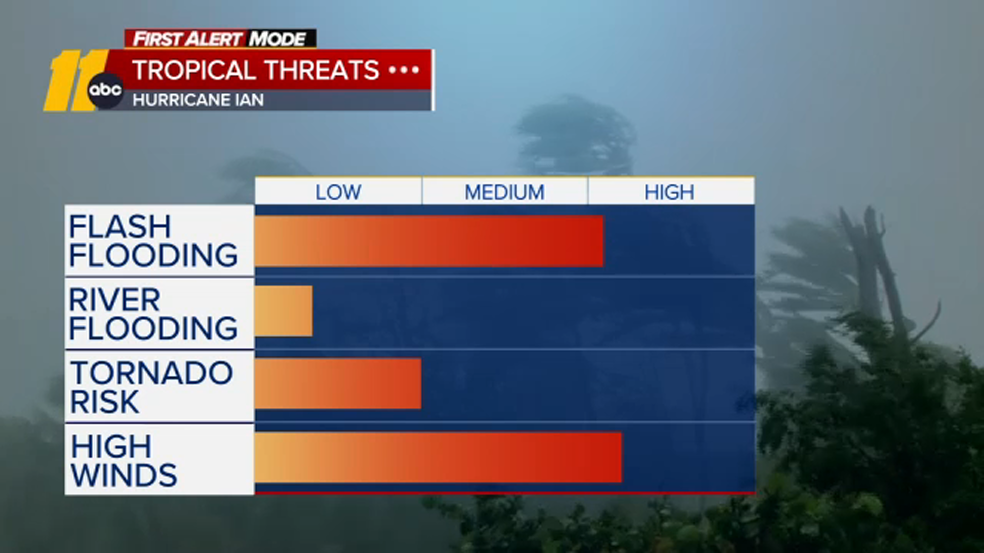
Storm threats
For North Carolina, wind and rain will be the biggest factors with this storm system.
Wind gusts, which started picking up Thursday, will continue through Friday with some gusts getting up to 50 or 60 miles per hour
Those strong winds combined with saturated ground could cause trees to topple, putting power lines at risk. Power crews across the state are on high alert and ready to respond as quickly as possible, but still it's likely that some people will be without power for at least a little while.
If you lose power, you should contact your power company. Here's a list of numbers to call and other power outage tips.
Widespread flooding and river flooding are not huge threats. However, flash flooding is a big concern. That's because some areas will see periods of heavy downpours.
As with most storms, tornados are possible. However, in this case they are not likely.
Big Weather's hurricane emergency kit
North Carolina prepares for Ian
On Thursday afternoon, Gov. Roy Cooper gave an update on state preparations.
Cooper urged North Carolinians to pay close attention to the weather and take necessary measures as the remnants of Hurricane Ian approach the state.
"Hurricane Ian reminds us how unpredictable these storms can be and North Carolinians should be prepared when it reaches our state," Cooper said Thursday. "Heavy rains, up to seven inches in some areas, are likely to bring some flooding. Landslides are a threat in our mountains and there's a chance of tornadoes statewide. Coastal flooding and gusty winds are likely as the storm passes through. This storm is still dangerous."
Several schools closed or opted for remote learning days. You can view the full list here